U.S. DEPARTMENT OF THE INTERIOR

BUREAU OF LAND
MANAGEMENT

SDARTT: INFORMATION
The Bureau of Land Management (BLM) and the United States Geological Survey (USGS) have partnered to create the Surface Disturbance Analysis and Reclamation Tracking Tool (SDARTT). SDARTT is to be the national repository for and analysis tool of disturbance data pertaining to public land operations for the BLM. Users will upload disturbance and reclamation data to SDARTT to map, analyze, and generate data reports. Spatial data will no longer be stored in the various current (or future) Data Management Systems (DMS). Instead the various DMS applications will have the ability to direct their users to SDARTT for data uploads, and the DMS applications will have access to the ever growing national pool of data.


Sage-Grouse
Habitat Management

Vision

FAQ
power
DRECP
Sage-Grouse Habitat Management
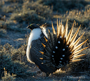
The BLM manages much of the best remaining sagebrush habitat for the Greater Sage-Grouse. As part of an unprecedented effort by dozens of partners across 11 western states, it has developed land use plans to conserve this habitat. These plans benefit not only the Greater Sage-grouse, but some other 350 other species of wildlife that rely on the sagebrush sea, and the many, many people who depend on it for their livelihoods and a source of recreation.

For more information about the conservation of the Sage-Grouse:

https://www.blm.gov/programs/fish-and-wildlife/sage-grouse


VISION
SDARTT is an interactive map tool used to document and track disturbance and reclamation efforts associated with surface activity requiring a BLM permit. This data is critical to the BLM’s public land use permitting process due to a number of BLM offices operating with disturbance cap requirements. This data can be cross-referenced with various background layers to assist in land use and natural resource management decisions. SDARTT can be used as a general, public, read-only application or, for approved users, can provide a variety of data uploading and editing capabilities as well. The three primary objectives of SDARTT are:

1) Develop a dynamic surface disturbance inventory: as-built and legacy disturbances, and four categories of reclamation data

2) Use the dynamic surface disturbance inventory to aid in siting and approving new proposed disturbances in support of numerous development and land use plans (i.e. site scale disturbance caps in sage-grouse ARMPAs, DRECP, etc.)

3) Allow users to view, download, and analyze data as needed for reporting purposes
FAQ
Where do I find the SDARTT User Manual?
To find the SDARTT User Manual click on the Resources tab and then click on the “New SDARTT User Manual” link.
How do I register to use SDARTT?
SDARTT is a secured application. Information can only been seen by users who have been given certain levels of access to the application depending upon the role they have assigned. To register click on the Register Button or go to: https://blm.sciencebase.gov/sdartt/authorizedUser/register
How do I choose which role to register as?
To determine whether to register as an Approver, Verifier, Editor, or Reader see the associated descriptions in the To Register section of the SDARTT User Manual. The download link for the SDARTT User Manual is located under the Resources tab.
How do I log into/launch SDARTT?
To log into/launch SDARTT click on the Launch Tool button above and login using the username and password you registered for SDARTT. You can also copy the login URL into a web browser: https://blm.sciencebase.gov/sdartt to access the SDARTT login page.
DRECP
The Desert Renewable Energy Conservation Plan (DRECP), a major component of California's renewable energy planning efforts, will help provide effective protection and conservation of desert ecosystems while allowing for the appropriate development of renewable energy projects.

The DRECP is focused on 22.5 million acres in the desert regions and adjacent lands of seven California counties – Imperial, Inyo, Kern, Los Angeles, Riverside, San Bernardino, and San Diego. It is an innovative landscape-level plan that streamlines renewable energy development while conserving unique and valuable desert ecosystems and providing outdoor recreation opportunities.

The DRECP is a collaborative effort between the California Energy Commission, California Department of Fish and Wildlife, the U.S. Bureau of Land Management, and the U.S. Fish and Wildlife Service, also known as the Renewable Energy Action Team.

The BLM signed the Record of Decision approving its Land Use Plan Amendment on September 14, 2016, completing Phase I of the DRECP. The BLM Plan Amendment covers the 10 million acres of BLM-managed lands in the DRECP plan area and supports the overall renewable energy and conservation goals of the DRECP.

Phase II of the DRECP focuses on better aligning local, state, and federal renewable energy development and conservation plans, policies, and goals. It includes building off of the Renewable Energy Conservation Planning Grants (RECPG) that were awarded by the California Energy Commission to counties in the plan area.

For more information:

https://www.drecp.org/
QUERY
WORDS
SDARTT Homepage BLM Landscape Tools